



(TheNewswire)
 | |||||||||
Rockport, Ontario Columbia – TheNewswire - November 17th, 2026 – MetalQuest Mining Inc. (TSX.V: MQM) ("MQM" or the "Company") is pleased to announce that it has received an independent technical report (the "Technical Report") on its 100%-controlled Superior Iron Project (the "Project") in northern Québec. The Technical Report was prepared by John Langton, M.Sc., P.Geo., of JPL GeoServices Inc., a Qualified Person as defined by National Instrument 43-101 ("NI 43-101"), with an effective date of August 14, 2026 and a signature date of October 15, 2026.
Highlights:
-
Field-verified geology: On August 5, 2026, Mr. Langton visited the Project, examined historical drill core stored at Camp Alpha, and confirmed that the rock types in the core match the units interpreted to underlie the Project.
-
Aerial reconnaissance: The site visit included an aerial examination of the Project area by float plane.
-
Two-phase program recommended: Mr. Langton recommends a $275,000 Phase 1 surface program, followed by a $715,000 Phase 2 trenching and diamond-drilling program, for a total of $990,000.
-
Two target types: The northern part of the Project is underlain by Sokoman Formation iron formation and the eastern part hosts Menihek Sub-Group rocks considered prospective for massive-sulphide and graphite mineralization.
-
New data pending: An airborne geophysical and LiDAR survey was recently concluded on the Project; results are being evaluated and will be reported separately.
The Project is a newly assembled, greenfield project comprising 510 exclusive exploration rights ("EER") covering 24,579 hectares (245.8 km²). It lies about 160 km northwest of Schefferville and 230 km south of Kuujjuaq, in the Kativik Territory of Nord-du-Québec. The EER form a horseshoe-shaped block that surrounds MQM's Lac Otelnuk iron project (“Lac Otelnuk”) (Figure 1).
Unlike Lac Otelnuk, which has seen decades of drilling, the Project has had only cursory exploration and has no defined resources. MQM acquired the EER for the Project to cover Sokoman Formation units that extend north from Lac Otelnuk and to secure ground for potential Lac Otelnuk infrastructure. The Project is on the ancestral lands of the Naskapi First Nation of Kawawachikamach, with whom MQM holds an Exploration and Pre-Development Agreement.
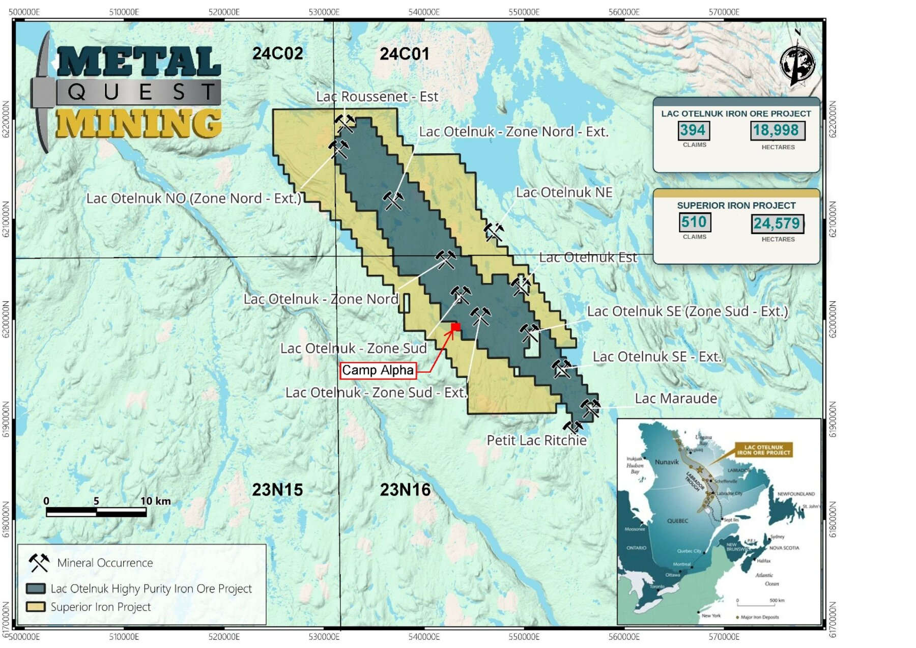
Click Image To View Full SizeFigure 1: Location of the Superior Iron Project relative to MetalQuest's Lac Otelnuk iron project. Source: Technical Report, Figure 1.1.
Figure 1: Location of the Superior Iron Project relative to MetalQuest's Lac Otelnuk iron project. Source: Technical Report, Figure 1.1.
The Project sits on the western front of the Labrador Trough, where iron formation of the Sokoman Formation is 75 to 150 m thick and grades 20–40% iron (Fe) in the Project area (Figure 2). One catalogued iron occurrence, Lac Roussenet East, lies in the northern part of the Project (see Figure 1).
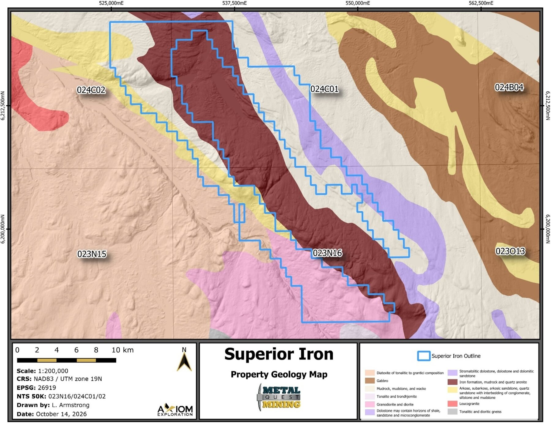
Click Image To View Full SizeFigure 2: General geology of the Project area; the dark red unit is iron formation. Source: Technical Report, Figure 6.4.
Figure 2: General geology of the Project area; the dark red unit is iron formation. Source: Technical Report, Figure 6.4.
The August 2026 Site Visit and Core Review
On August 5, 2026, John Langton travelled to the Project to see the ground first-hand and examine historical drill core stored at Camp Alpha (see Figure 1 and Figure 3), along with Faraz Rasheed (Advisor – MQM). His key finding: the rock types in the core match those interpreted to underlie the Project, namely the Ashuanipi, Seward, Pisolet, Wishart, Ferriman and Menihek units. This is the same stratigraphic package that hosts iron formation underlying Lac Otelnuk.
The Project is realistically accessible only by air. Helicopters and float planes can reach it from Schefferville, Kuujjuaq or the Lac Pau Water Aerodrome at the end of the Trans-Taiga Highway, 160 km to the southwest. During the visit, Mr. Langton made an aerial examination of the Project by float plane, assessing the general landscape and surface features across the claim block.
Camp Alpha is a legacy exploration camp on the shore of Lac Alpha, built by Adriana Resources during its exploration of Lac Otelnuk (Figure 3). The camp retains warehouse- and garage-type structures and an area cleared for a winter airstrip.
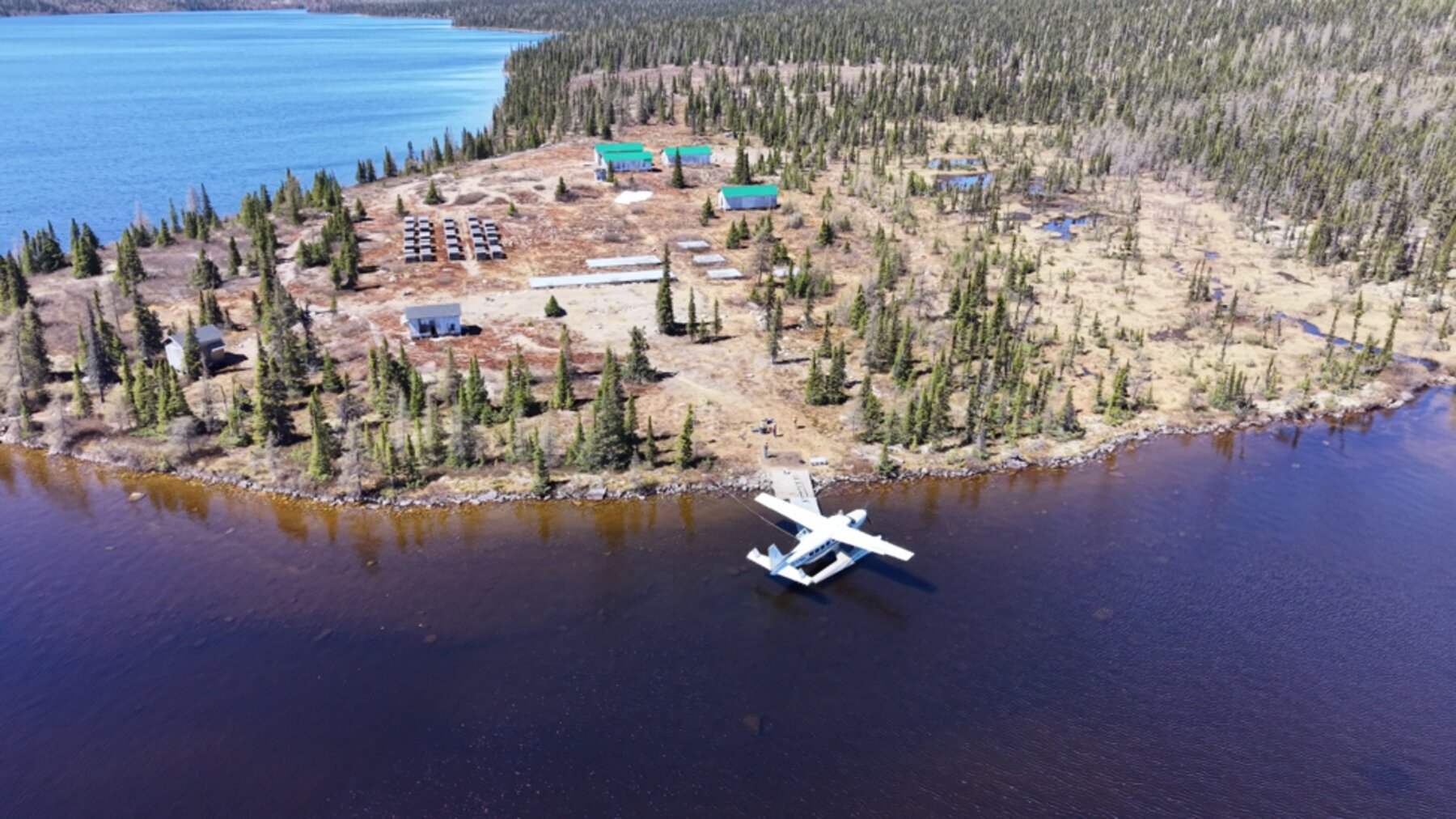
Click Image To View Full SizeFigure 3: Drone image of Camp Alpha, summer 2026, where historical drill core was examined during the site visit. Source: Technical Report, Figure 1.2.
Figure 3: Drone image of Camp Alpha, summer 2026, where historical drill core was examined during the site visit. Source: Technical Report, Figure 1.2.
Several historical Adriana holes were collared inside the Project boundary (Figure 4). Hole PQ-1109 was drilled at Camp Alpha itself to test for an artesian water supply and the iron formation footwall; it hit artesian flow at 24 m and was stopped. Holes LO-N-1115, LO-N-1116 and LO-N-1134 are also within the Project.
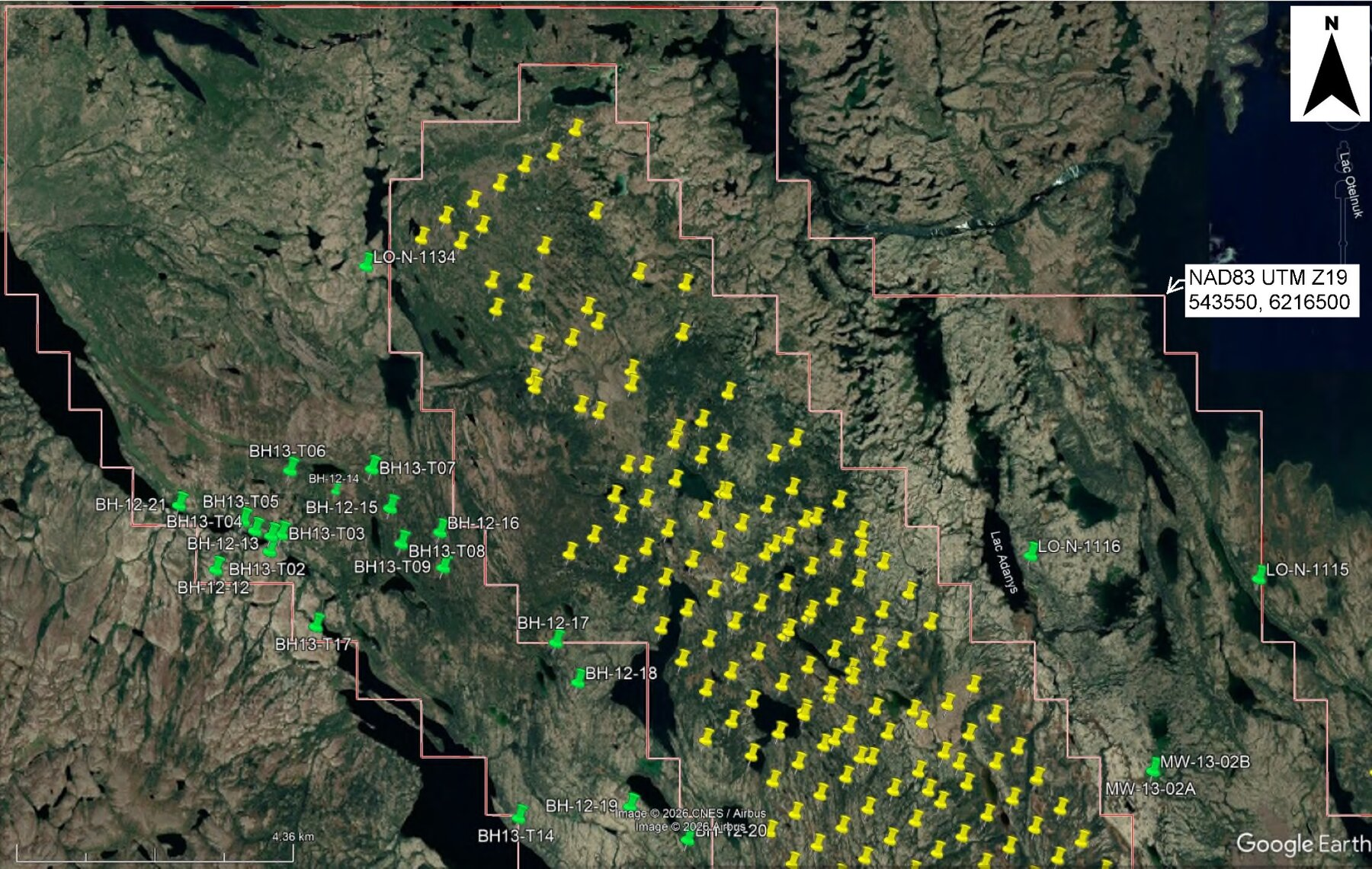
Click Image To View Full SizeFigure 4: Historical Adriana/LOM drill holes in the northern Project area. Green pins are holes inside the Project boundary (red outline); yellow pins are Lac Otelnuk resource holes. Source: Technical Report, Figure 5.4.
Figure 4: Historical Adriana/LOM drill holes in the northern Project area. Green pins are holes inside the Project boundary (red outline); yellow pins are Lac Otelnuk resource holes. Source: Technical Report, Figure 5.4.
Beyond the site visit, Mr. Langton is responsible for every section of the Technical Report. His work included:
-
Reviewing and validating all Project information supplied by MQM, including its 2026 exploration work.
-
Compiling regional geology and mineral occurrence data from Québec's SIGEOM database and historical assessment reports.
-
Confirming through the GESTIM system that all 510 EER were in good standing as of the effective date.
-
Interpreting the Project's geology and setting the exploration priorities and budget described below.
Mr. Langton is independent of MQM; his fees were not contingent on the report's results. Harry Barr had the following comments upon completion of this report:
" We assembled Superior Iron to surround Lac Otelnuk and to follow the Sokoman Formation beyond it. Having an independent Qualified Person walk the ground, examine the core at Camp Alpha and confirm the geology is an important first step in turning that strategy into an exploration program. We are pleased to have a clear, staged plan for Superior Iron. Alongside the iron potential in the north, the report identifies the Menihek rocks in the eastern arm as prospective for massive sulphides and graphite, which gives us a second type of target to test. We look forward to reporting the airborne survey results and outlining our Phase 1 plans.”
Recommendations: A Two-Phase, $990,000 Exploration Program
Mr. Langton recommends a staged program totalling $990,000: a $275,000 Phase 1 to generate targets, followed by a $715,000 Phase 2 to test them by excavation and diamond-drilling. Phase 2 is contingent on a successful Phase 1.
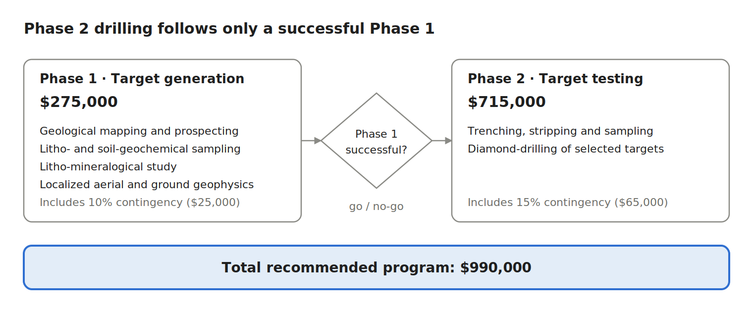
Click Image To View Full SizeFigure 5: The recommended two-phase program. Phase 2 trenching and drilling proceeds only if Phase 1 defines anomalous geochemistry or mineralization. Source: Technical Report, Table 12-1.
Figure 5: The recommended two-phase program. Phase 2 trenching and drilling proceeds only if Phase 1 defines anomalous geochemistry or mineralization. Source: Technical Report, Table 12-1.
The Technical Report describes the Project as essentially virgin territory, with little geological or litho-geochemical data. It lies both across and along strike from the Lac Otelnuk iron deposit, but mineralization there is not necessarily indicative of mineralization on the Project. Mr. Langton therefore advises building a consistent dataset first, then spending on drilling only where the data point.
Phase 1 – Target generation ($275,000)
In an underexplored area, Mr. Langton identifies a representative, internally consistent geochemical dataset of pathfinder and indicator elements as the most important first step. Phase 1 combines:
-
Geological mapping and prospecting of bedrock exposures, checking them for pathfinder elements.
-
Litho-mineralogical study and detailed mineralogical analysis of rock samples.
-
Tailored soil geochemical sampling, which with rock sampling provides the main vectors toward mineralization.
-
Localized aerial and ground geophysical surveys to sharpen targets.
Used together, these tools are meant to rank the areas of highest potential across the Project. The work is best suited to the spring-to-fall field season.
Phase 2 – Target testing ($715,000)
If Phase 1 succeeds, Phase 2 moves to surface excavation and drilling of the best targets: trenching, stripping and bulk sampling, then diamond-drilling. Drilling and ground geophysics can be carried out year-round.
-
Iron (northern Project): The distribution and extent of Sokoman Formation iron formation in the north needs to be better established. Targets will be verified by mapping and sampling, then surface excavation and diamond-drilling.
-
Massive sulphides and graphite (eastern "arm"): Menihek Sub-Group rocks, including graphitic mudstone, are considered prospective for exhalative massive-sulphide and graphite mineralization. Mr. Langton recommends electromagnetic (EM) and magnetic surveys, then prospecting of anomalies, followed by surface excavation and diamond-drilling.
|
Phase |
Activity |
Amount (CAD) |
|
Phase 1 |
Mapping/prospecting, litho- and soil-sampling, localized geophysical surveys |
$250,000 |
|
Phase 1 |
Contingencies (10%) |
$25,000 |
|
Phase 1 total |
$275,000 |
|
|
Phase 2 |
Trenching/stripping/sampling |
$100,000 |
|
Phase 2 |
Diamond-drilling |
$550,000 |
|
Phase 2 |
Contingencies (15%) |
$65,000 |
|
Phase 2 total |
$715,000 |
|
|
Grand total |
$990,000 |
Source: Technical Report, Table 12-1.
The recent airborne geophysical and LiDAR survey gives Phase 1 a head start: MQM is evaluating those results and will report them separately. MQM also plans to integrate Project targeting into its staged development plan for Lac Otelnuk, following the 2025 Gap Analysis Report (Donnini and Cloutier, 2025).
The scientific and technical information in this news release is derived from the Technical Report prepared by John Langton, M.Sc., P.Geo., of JPL GeoServices Inc., an independent Qualified Person as defined by NI 43-101, who has reviewed and approved the technical information in this news release.
Historical Estimates
Any reference to historical mineral resource estimates on the adjacent Lac Otelnuk property is historical in nature and should not be relied upon. A qualified person has not done sufficient work to classify the historical estimates as current mineral resources or mineral reserves, and the key assumptions, parameters and methods used to prepare them are unknown. MQM is not treating them as current mineral resources or mineral reserves. Mineralization on Lac Otelnuk is not necessarily indicative of mineralization on the Project, which is an early-stage project with no defined resources.
About MetalQuest Mining Inc.
MetalQuest Mining Inc. is a Canadian exploration company focused on iron and critical minerals. Its portfolio includes the 100%-owned Lac Otelnuk Iron project in the Labrador Trough of northern Québec, which is supported by a historic feasibility study completed in 2015, the Superior Iron project, and the ROF-1 and Fishhook Polymetallic projects in Ontario’s Ring of Fire. In the Kenora mining district, MetalQuest is exploring the West and East Cameron gold projects. The Company also holds two NSR royalties totaling 1% on the Murray Brook polymetallic deposit in New Brunswick, as well as shares and warrants of Canadian Copper Inc. New Age Metals Inc. is an approximate 14% shareholder of MetalQuest Inc. As of October 22nd 2026, MetalQuest Mining Inc. applied to the Province of Ontario for a 21-year mining lease over the former Timminco (Haley Station) Magnesium Mine, Renfrew County, Ontario. https://metalquestmining.com/news/metalquest-mining-applies-to-the-province-of-ontario-for-a-21-year-mining-lease-over-the-former-timminco-haley-station-magnesium-mine-renfrew-county-ontario/ . As the 2026 exploration programs are coming to an end throughout our project portfolio, management plans to give its shareholders an overview of all the milestones, highlights, and go-forward plan for 2027.
Investors are invited to visit the MetalQuest website at www.metalquestmining.com where they can review the Company and its corporate activities. Any questions or comments can be directed to Harry Barr at Hbarr@mqmining.com or Connor Barr at connorbarr@mqmining.com.
Opt-in List
If you have not done so already, we encourage you to sign up on our website
(www.metalquestmining.com) to receive our updated news.
On behalf of the Board of Directors and Management, we thank you for your continued
support and trust in MetalQuest Mining.
Harry G. Barr
Chairman and CEO
Neither the TSX Venture Exchange nor its Regulation Services Provider (as that term is defined in the policies of the TSX Venture Exchange) accepts responsibility for the adequacy or accuracy of this release. Cautionary Note Regarding Forward Looking Statements: This release contains forward-looking statements that involve risks and uncertainties, including statements regarding the Company's application for a mining lease over the former Timminco magnesium property, the review process for that application, the possibility that a lease may be granted and the terms on which it may be granted, the Company's proposed engagement with Indigenous communities and municipalities, the proposed staged work program and its timing, the potential of the high-purity dolomitic marble, and the market for magnesium. There is no assurance that the Ministry or the Lieutenant Governor in Council will approve the application, that a lease will be granted on terms acceptable to the Company or at all, or as to the timing of any decision. Factors that could cause actual results to differ materially include, among others, the discretionary nature of tenure under subsection 176(3) of the Mining Act, the outcome of the Class Environmental Assessment, Environmental Registry of Ontario and Crown consultation processes, the allocation of historical environmental liabilities, the availability of financing, the results of exploration, metallurgical and engineering work, and magnesium market conditions. These statements may differ materially from actual future events or results and are based on current expectations or beliefs. For this purpose, statements of historical fact may be deemed to be forward-looking statements. In addition, forward-looking statements include statements in which the Company uses words such as "continue", "efforts", "expect", "believe", "anticipate", "confident", "intend", "strategy", "plan", "will", "estimate", "project", "goal", "target", "prospects", "optimistic" or similar expressions. These statements by their nature involve risks and uncertainties, and actual results may differ materially depending on a variety of important factors, including, among others, the Company's ability and continuation of efforts to timely and completely make available adequate current public information, additional or different regulatory and legal requirements and restrictions that may be imposed, and other factors as may be discussed in the documents filed by the Company on SEDAR+ (www.sedarplus.ca), including the most recent reports that identify important risk factors that could cause actual results to differ from those contained in the forward-looking statements. The Company does not undertake any obligation to review or confirm analysts' expectations or estimates or to release publicly any revisions to any forward-looking statements to reflect events or circumstances after the date hereof or to reflect the occurrence of unanticipated events. Investors should not place undue reliance on forward-looking statements.
-
Langton, J., 2026. Technical Report for the Superior Iron Project, Kativik Territory, Northern Québec, Canada. Prepared by JPL GeoServices Inc. for MetalQuest Mining Inc. Effective date August 14, 2026; signed October 15, 2026. Source of all figures and tables in this release.
-
Donnini, P. and Cloutier, J.P., 2025. Lac Otelnuk Project / Gap Analysis Report. AtkinsRéalis Technical Report, Project 706178, for MetalQuest Mining; Reference 706178-0000-30RA-001_00, 38 p.
-
Risto, R.W., Kociumbas, M.W., Martinez, R., Lord, J., Giroux, E., Côté, M., Buccitelli, S., Cassoff, J. and Boilard, A., 2015. Lac Otelnuk Project Feasibility Study – NI 43-101 Technical Report, for Lac Otelnuk Mining, 459 p.
-
Gross, G.A., 1995. Stratiform iron: Lake Superior-type iron-formation, Algoma-type iron-formation, Ironstone. In: Geology of Canadian Mineral Deposit Types, Geological Survey of Canada, Geology of Canada Series no. 8, pp. 41–80.
-
Clark, T. and Wares, M., 2005. Lithotectonic and metallogenic synthesis of the New Quebec Orogen (Labrador Trough). Ministère des Ressources naturelles, Québec, MM 2005-01, 175 p.
-
GESTIM (Gestion des titres miniers). Province of Québec online mining title management system: gestim.mines.gouv.qc.ca

Copyright (c) 2026 TheNewswire - All rights reserved.
